Benefits of Using ECDIS Over Paper Charts for Marine Navigation
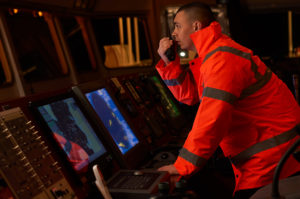
The Electronic Chart Display and Information System (ECDIS) is a sophisticated route charting, planning, and navigational system that allows members of the Marines Corps to accurately map out their voyages and minimize risk along the way. This innovative technology has been proven to help companies avoid and mitigate potentially dangerous situations such as poor weather conditions, natural disasters, and security threats by accurately alerting crewmembers of impending risks and helping them reroute their initial trajectories. Not only is this essential to the safety and survival of Marines Corps officers, but it’s also useful for ensuring national security.
How Does ECDIS Work?
The purpose of ECDIS is to replace paper charts altogether and make them obsolete. ECDIS works in conjunction with rugged Marines displays and other technologies including GPS (Global Positioning Systems) and in compliance with the SOLAS Convention to enhance overall navigational safety procedures.
ECDIS also takes a lot of pressure off of crew navigators by informing them of potential risks on route to their destination and offering safer alternate route options. Ship navigators can use this information to then gauge the safety risks of their projected routes and make necessary updates and adjustments.
What Are the Advantages of Using ECDIS Technology?
Aside from the heightened safety intel, there are a lot of advantages to using ECDIS technology in Marines operations.
Here are just a few of them:
Real-Time Monitoring
As mentioned, ECDIS allows for the utmost accuracy when it comes to real-time monitoring. Navigators receive up-to-the-minute updates regarding their current route trajectory. In the event of a potential security or safety risk, the system will present them with a number of possible route alternatives that are much safer.
User-Friendly Interface
Even though Marine Corps crewmembers and navigators are highly trained in the latest navigational technology, it’s still important to ensure that the interface is as user-friendly and easy to comprehend as possible. This is especially true in light of potential danger when convenience and expediency are huge assets.
To make operations quick and convenient, ECDIS uses a number of other navigational equipment and softwares including Echo Sounder, GPS, RADAR, Gyro, and ARPA.
Alarms and Warning Signals
In addition to providing the ship navigator with visual and audible indications that the vessel is headed in a dangerous direction, loud alarms and warning signals will also notify the rest of the crew so that they can act quickly in the event of an emergency. This feature also relieves the ship navigator from the stressful task of having to individually notify other crewmembers, allowing them to focus on swiftly mapping out a new route.
Unparalleled Accuracy
Aside from being able to provide safe travel alternatives for Marines Corps vessels, rugged displays like ECDIS should have the capacity to accurately predict the estimated time of arrival to their destinations so that crewmembers and inland officers can aptly prepare for the mission. Another important point is that sometimes traditional charts might mistake large sea creatures or inanimate objects like debris for potential threats. To prevent unnecessary rerouting from happening, ECDIS uses precision-enhanced technology to help navigators identify these objects from great distances.
Interested in learning more about ECDIS, rugged displays, and Marines technology? Contact Nauticomp Inc., North America’s leading designer and supplier of advanced Marines displays.